
Published: 1:18 PM, May 15, 2020; updated: 7:44 PM, May 15, 2020
With the rising heat index in the past few weeks and most of Metro Manila in community quarantine, the question of whether water supply will be enough arises — especially in the face of the COVID-19 pandemic. This predicament, however, can hopefully be eased by the rain coming from Typhoon Ambo, researchers say.
Researchers from University of the Philippines Diliman and Department of Science and Technology-Advanced Science and Technology Institute (DOST-ASTI) used both on-ground and spaceborne data to monitor and predict the water levels of Angat Dam and La Mesa Dam — two of Metro Manila’s main water reservoirs.
Home to almost 14 million people, Metro Manila needs at least 4000 million liters of water daily. This water is supplied by the Angat Dam, located north of the metro. Water from this flows directly to the nearby Ipo Dam before going straight to La Mesa Dam, completing the water system that provides most of the region’s water supply¹. However, these dams are susceptible to the seasonal fluctuations and dry spells.
Using data from Synthetic Aperture Radar (SAR) satellite, Sentinel-1, correlated with on-ground water level measurements of the dams, the researchers from the Space Technology and Applications Mastery, Innovation and Advancement (STAMINA4Space) Program tracked the water levels of Angat Dam and La Mesa Dam from February 2015 to April 2020.
In general, the water level in Angat Dam shows a seasonal pattern, wherein a decreasing trend can be observed during dry seasons. During the dry seasons of the year, high temperature increases evaporation, affecting water and agricultural systems. The heat also raises household consumption. This, alongside lesser rainfall, can easily deplete the dams. These seasonal changes in water level is depicted in Figure 1 when La Mesa dam experienced a record low in its water level last year².
Figure 2. Metropolitan Waterworks and Sewerage System (MWSS) in situ measurement and Synthetic Aperture Radar (SAR) estimate of water level in Angat. Available in situ measurements of dam level from MWSS spans from May 2017 to April 2020 while measurements from SAR images can be inferred as early as February 2015. Forecast 1 denotes the SARIMAX model whereas Forecast 2 pertains to the 2017 Trend fit. [Source: Drought and Crop Assessment and Forecasting (DCAF) Project. Details on forecast methodologies can be provided by DCAF thru dcafphase2@gmail.com)
But will water supply be enough this year, especially with the heightened need for it in order to maintain proper hygiene during a pandemic? Data suggests it will be enough, but water conservation is still a must.
Using the SAR-based water level estimates, researchers from the Ground Receiving, Archiving System, Science Product Development and Distribution (GRASPED) Project of STAMINA4Space Program and Drought and Crop Assessment Forecast (DCAF) Project generated a four-month statistical forecast of water level in Angat and La Mesa Dams. Both projections show that the current water level will continue to decline, with one of the models predicting that the water level in Angat Dam will fall below the minimum operating level as early as June this year.
However, Typhoon Ambo may augment the water supply, providing an increased water volume in Angat and La Mesa Dams as it passes the country. This could help maintain sufficient water supply especially in the face of the COVID-19 pandemic when proper hygiene should be observed.
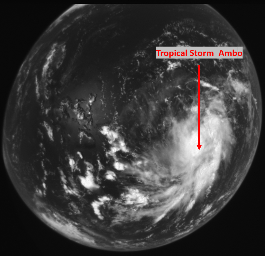
According to Philippine Atmospheric, Geophysical and Astronomical Services Administration’s latest bulletin issued 5:00 PM today, Typhoon Ambo made its seventh landfall in Quezon with winds of up to 100 kph and gustiness of 140 kph³. Diwata-2 captured a wide field camera image of Ambo on May 12, 2020, two days before it made landfall in the country when it was still a tropical storm.
Figure 3. Wide Field Camera image of TS Ambo on May 12, 2020 (01:08 PM), two days before it made its first landfall in the Philippines and became a typhoon. Note that the WFC uses a fish-eye lens camera giving the image its distorted appearance. (Source: Project GRASPED of STAMINA4Space Program)
Measuring Dams Using Satellite Images
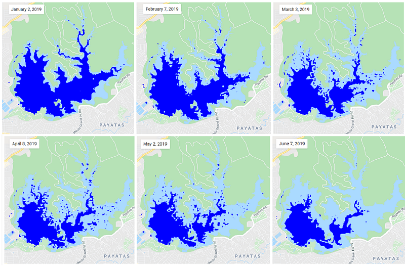
Traditionally, dams’ water levels are measured on-ground. However, these water reservoirs can also be measured using satellite imagery, effectively covering larger areas and concisely mapping out data. Optical satellites can be used to see the extent of water in dams, as shown in Figure 4where images of La Mesa Dam were in January, March and May this year to see the possible extent of water.
Figure 4. The blue parts depict the possible extent of water in La Mesa Dam in January, March, and May 2020 derived from Dove Satellite Images. [Source: Remote Sensing and Data Science (DATOS) Help Desk and Philippine Earth Data Resource and Observation (PEDRO) Center]
SAR sensors like the one onboard Sentinel-1 satellite emit microwaves to the surface, measuring its intensity and return time to provide information on the ground’s features, as shown in Figure 5. Because most SAR satellites rely on active sensing to gather data, these satellites can help in measuring the dams in almost all-weather conditions. And because they are in space, satellites are not vulnerable to man-made and natural disturbances such as floods and earthquakes.
These, among other advantages, can be tapped as the country continues to discover and use the vantage point of space in obtaining data about Earth.
Figure 5. An illustration of how radar satellites acquire images. (Source: STAMINA4Space Program — Project GRASPED)
References:
¹ Metro Manila Water Supply System. http://mwss.gov.ph/learn/metro-manila-water-supply-system [Online; accessed 2020–05–05].
² La Mesa Dam water breaks critical level. https://newsinfo.inquirer.net/1094150/la-mesa-dam-water-breaks-critical-level [Online; accessed 2020–05–06]
³ Severe Weather Bulletin #23: Typhoon “Ambo”. http://bagong.pagasa.dost.gov.ph/tropical-cyclone/severe-weather-bulletin/2
Significant decline in chlorophyll-a and turbidity was already observed by March 28.
For more Diwata images, visit the Featured Image page.
- Connect to DATOS on Facebook
- Email: datos@asti.dost.gov.ph
- Connect to PEDRO Center on Facebook: facebook.com/ThePEDROCenter
- For inquiries, send an email to: grs@asti.dost.gov.ph
Drought and Crop Assessment and Forecasting (DCAF)
- The project exists as an initiative to mitigate effects of drought in the Philippines using technologies like satellite imagery, GPS, climate models, and other geospatial tools. The project is part of an even bigger scheme, Program SARAI (Smarter Approaches to Reinvigorate Agriculture as Industry in the Philippines), which aims to provide advisories on different crops (rice, corn, sugarcane, banana, cacao, coffee, tomato, soybean, and coconut) in the nation. As one of the projects of SARAI, DCAF demonstrates the important role of remote sensing in providing real-time data that are readily available on a monthly basis, from the farm level up to a national scale.
- Email: dcafphase2@gmail.com