
The Diwata-1 image below shows a stark difference between a highly urbanized metropolitan city (in the center) and a less developed rural region (in the North). The areas covered here include Metro Manila and portions of Rizal, Cavite, Laguna, and Laguna Lake. Metro Manila, the Philippines’ National Capital Region (NCR), is the country’s busiest and most developed region.
According to the latest report by the Census of Population and Housing (CPH), Metro Manila has a population of 12,877,253 as of August 2015 (POPCEN 2015). The population densely occupies a total land area of 63,600 hectares, more than half of which are classified as residential/commercial).¹ The current population is significantly higher by 1.02 million than the 11.86 million population in 2010, and by 2.94 million compared with the 9.93 million population in 2000.² In effect, a huge portion of land is converted to human spaces. The remaining vegetation in the urban area is now enclosed by a modified environment, visible in the center of the image as small, green patches.
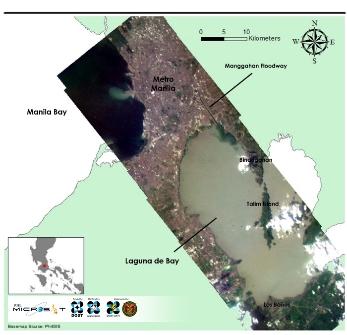
Agricultural lands are more noticeable in the lower portion, which covers Laguna. Since these areas are also represented as green patches, we rely on its location to provide clues on what type of vegetation the area most likely has. Land is usually limited inside cities so agriculture settles along its fringes. Farming would settle near markets to supply demand. In the north, Bulacan (not visible in the Diwata image) remains a valuable asset for agriculture due to its high potential for irrigation, but less so in the south, especially Cavite, where lands are lesser in value and are thus converted to built-up.³ At present, agriculture is pushed to the south, and as seen in the Diwata image, situated along the southern coast of Laguna Lake. These factors help us interpret that these areas are used for growing crops.
In the figure above, effluent deposits in Manila Bay are clearly seen in the mouth of Pasig River. The effluents dumped in the bay in this area are the culmination of waste disposal to the river by the multiple cities it crosses, which use the water body as a waste outlet. Studies report the presence of materials of anthropogenic origin such as plastics,⁴ flame retardant compounds,⁵ and industrial chemicals⁶ in the tissues of marine organisms within the bay.
References
¹ Retrieved from http://ncr.denr.gov.ph/index.php/about-us/regional-profile
² Retrieved from https://psa.gov.ph/content/population-national-capital-region-based-2015-census-population-0
³ Malaque III, I. R., & Yokohari, M. (2007). Urbanization process and the changing agricultural landscape pattern in the urban fringe of Metro Manila, Philippines. Environment and Urbanization, 19(1), 191–206.
⁴ Kim, J. W., Isobe, T., Ramaswamy, B. R., Chang, K. H., Amano, A., Miller, T. M., … & Tanabe, S. (2011). Contamination and bioaccumulation of benzotriazole ultraviolet stabilizers in fish from Manila Bay, the Philippines using an ultra-fast liquid chromatography–tandem mass spectrometry. Chemosphere, 85(5), 751–758.
⁵ Kim, J. W., Isobe, T., Chang, K. H., Amano, A., Maneja, R. H., Zamora, P. B., … & Tanabe, S. (2011). Levels and distribution of organophosphorus flame retardants and plasticizers in fishes from Manila Bay, the Philippines. Environmental pollution, 159(12), 3653–3659.
⁶ Carvalho, F. P., Villeneuve, J. P., Cattini, C., Tolosa, I., Bajet, C. M., & Navarro-Calingacion, M. (2009). Organic contaminants in the marine environment of Manila Bay, Philippines. Archives of environmental contamination and toxicology, 57(2), 348–358.
Read more about Diwata-1 or browse, download, or request for Diwata-1 images.