
A series of volcanic activities that began on January 13, 2018 ¹ made Mayon Volcano a high-priority target for Diwata-1. Within two weeks of continuous volcanic activity, Mayon was successfully captured by the microsatellite’s Middle Field Camera (MFC) on January 30, 2018 at 12:47 PM.
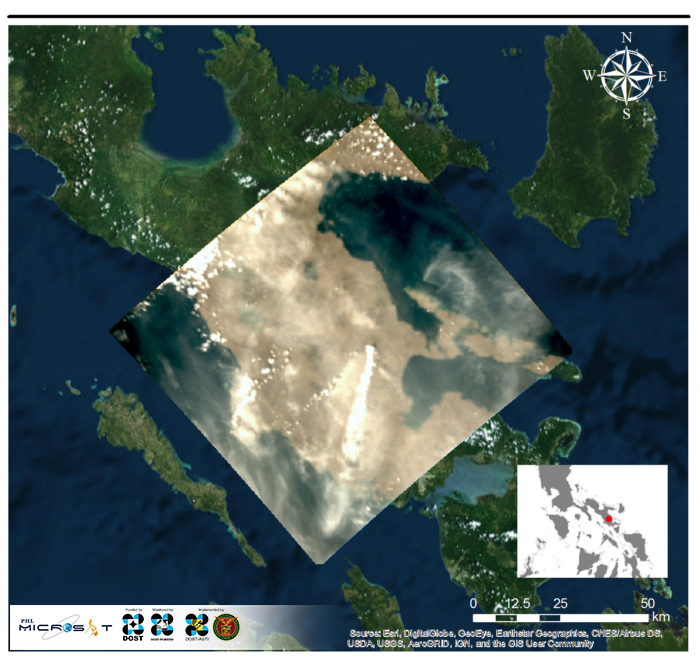
The image above includes portions of Albay, with the volcanic plumes coming from Mayon Volcano vividly depicted as a bright white streak near the center of the image. Wind simulations show that the wind direction in the area during the acquisition time was coming from the northeast.² This coincides with the observed dispersion of plumes relative to the volcano. Other portions of the image appear whitish due to high cloud cover during the acquisition time.
According to the Philippine Institute of Volcanology and Seismology (PHIVOLCS) a “lava-collapse fed Pyroclastic Density Current (PDC) event occurred on Miisi Gully, producing a 1250-meter high ash cloud that drifted southwest” at 11:51 AM on January 30. It was followed by two more PDC events on the Basud Gully, which continued until 12:09 PM and produced ash clouds that drifted southwest, with “low whitish to light-gray plumes” emitted continuously from the crater throughout the day. Diwata-1’s image above captured the aftermath at 12:47 PM.³ Today, the area remains on Alert Level 4.
Volcanic eruptions are known to release both mineral particles (ash or tephra) and sulfate precursor gases (predominantly sulfur dioxide). Sulfate aerosols are effective scatterers of sunlight and have long lifetimes, hence they can alter the climate. Substantial amounts of SO2 gas injected into the stratosphere can have a significant cooling effect that can last for a few months or years.⁴ A similar event happened in 1991 when Mt. Pinatubo erupted and the large aerosol cloud caused a dramatic decrease in net solar radiation reaching the Earth’s surface. This caused a decrease in temperature as large as -0.4 degrees Celsius over large parts of the globe in 1992–93.⁵ If Mayon continues to emit volcanic aerosols, it would be interesting to see if the area will also experience a notable decrease in temperature.
An active stratovolcano and famous landmark in Albay known for its perfect conical shape, Mayon Volcano is the Philippines’ most active volcano and one of the most active in the world, having erupted over 50 times in the past four centuries.⁶ Its most destructive eruption was on the 1st of February in 1814, taking 1,200 casualties in Albay.
Despite the destruction it is capable of, the picturesque volcano and its rich, surrounding landscape holds a unique kind of beauty that has earned the title of being the country’s first national park on July 20, 1938 (later reclassified as Mayon Volcano National Park in 2000).⁷
References
¹ Philippine Institute of Volcanology and Seismology. “Mayon Volcano Bulletin 13 January 2018 8:00 AM.” [http://www.phivolcs.dost.gov.ph/index.php?option=com_content&view=article&id=8329:mayon-volcano-bulletin-13-january-2018-800-am-&catid=70:latest-volcano-bulletin&Itemid=500008]. 13 January 2018.
² Jay Samuel Combinido. Sub-dataset of the NOAH-WISE WRF Model 12-km 8-day Forecast, GIS-compatible Product dataset.[https://asti.dost.gov.ph/coare/data/datasets/wrf-001-gis/wrf-001-gis-201801/resource/3469f032-47ff-4c0b-8e63-0d45171bf3cc]. 31 December 2017.
³ Philippine Institute of Volcanology and Seismology. “Mayon Volcano Bulletin 31 January 2018 8:00 AM.” [http://www.phivolcs.dost.gov.ph/index.php?option=com_content&view=article&id=8407:mayon-volcano-bulletin-31-january-2018-0800-am&catid=70:latest-volcano-bulletin&Itemid=500008]. 31 January 2018.
⁴ Myhre, G., D. Shindell, F.-M. Bréon, W. Collins, J. Fuglestvedt, J. Huang, D. Koch, J.-F. Lamarque, D. Lee, B. Mendoza, T. Nakajima, A. Robock, G. Stephens, T. Takemura and H. Zhang, 2013: Anthropogenic and Natural Radiative Forcing. In: Climate Change 2013: The Physical Science Basis. Contribution of Working Group I to the Fifth Assessment Report of the Intergovernmental Panel on Climate Change [Stocker, T.F., D. Qin, G.-K. Plattner, M. Tignor, S.K. Allen, J. Boschung, A. Nauels, Y. Xia, V. Bex and P.M. Midgley (eds.)]. Cambridge University Press, Cambridge, United Kingdom and New York, NY, USA.
⁵ Self, S., Zhao, J., Holasek, R., Torres, R., King, A.“The Atmospheric Impact of the 1991 Mount Pinatubo Eruption, United States Geological Survey.” [https://pubs.usgs.gov/pinatubo/self/]. 1999.
⁶ Philippine Institute of Volcanology and Seismology. “Mayon Volcano Historical Eruptions.” [http://www.phivolcs.dost.gov.ph/html/update_VMEPD/vmepd/vmepd/MV_HistEruptions.pdf].
⁷ Philippine National Commission for UNESCO. “Mayon Volcano Natural Park (MMVNP).”[http://whc.unesco.org/en/tentativelists/6007/]. 20 March 2015.
Read more about Diwata-1 or browse, download, or request for Diwata-1 images.