
Volcanoes have been reminding the world of their power lately, with major volcanic activities observed (and for some, felt) in different parts of the world. As of writing, Mount Agung in Bali, Indonesia shows heightened activity that prompted the Indonesian government to suspend tourist activities and evacuate residents living near the crater starting late September, while residents of Vanuatu’s northern island, Ambae, have also been evacuated as the Manaro Voui threatens a possible eruption by spitting rock and ash at around the same time. Around dawn of October 11, Mount Shinmoe in Japan’s Kirishinmoe mountain range erupted — its first sign of activity in about six years — showering three cities with some ash, but luckily without causing damage or injury.¹
The power of volcanoes are both catastrophic and constructive, with the Philippines experiencing both firsthand. Just at the southernmost tip of the Luzon lies Bicol, whose abundance of different natural resources and environmental features offer a glimpse of how highly volcanic activity uniquely shapes a region nestled in the Pacific Ring of Fire. The presence of volcanoes, crater lakes and hot springs starting from Mount Labo in Camarines Norte down to the Gate Mountains in Matnog, Sorsogon is a strong evidence of volcanism in the region.²
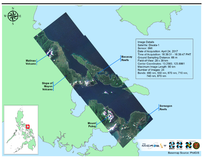
On April 24, 2017, Diwata-1, captured an image that encompasses the rich landscape and natural resources of the region (Figure 1). The scene extends from the Atulayan Island in Camarines Sur down to San Bernardino Strait in Sorsogon, a portion of Malinao Volcano and the Tiwi Geothermal Powerplant (the first geothermal powerplant commissioned in the Philippines)², the eastern slope of the Mayon Volcano in the municipalities of Malilipot and Santo Domingo in Albay, and the lush and forested Mount Pulog in Bacon, Sorsogon. In addition, coral reefs of Bacacay and Rapu-rapu area in the eastern part of Albay and in Sorsogon City and Prieto Diaz in Sorsogon were also captured.
From eruption to natural reconstruction
Inarguably, the Mayon Volcano has earned the region a lot of recognition with its coveted conical shape. Bicol’s total land area spans 1,763,250 hectares, with 541,189 hectares being established as forestland.³ It also has a thriving agriculture that can be greatly owed to its volcanic nature. From the classification map (Figure 2), majority of the bare agricultural areas are located in the foothills of Mayon and Malinao volcanoes. The volcanic deposits from the previous eruptions of these two volcanoes contributed to the fertile soil in those locations that are well-suited to nurture agricultural crops. Volcanic ash soils are known as the most productive soils in the world due to their ability to accumulate large amounts of organic carbon and nitrogen and store plentiful amount of water. The periodic additions of volcanic ash in an area generally improve the soil physical and chemical properties and renew the soil productivity.⁴ Multiple eruptions of Mayon Volcano including the destructive ones in 1766, 1814, 1853, 1897 and 1991⁵ resulted to the flourishing agriculture in the region at present time. Moreover, the lush vegetation covering the volcanic centers is a clear evidence of the beneficial impact of the volcanic features in the region. Albay alone is home to 182 terrestrial plant species including 46 endemic species.
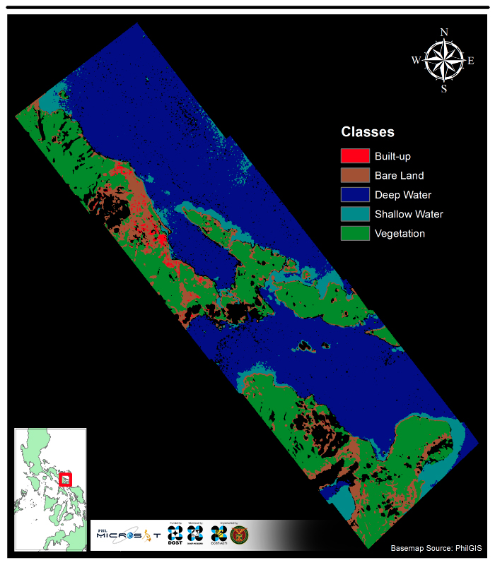
Figure 2. Land cover classification of Diwata-1 image in Bicol Region. Using the 490, 550, 670 and 870 nm bands captured by the SMI sensor, the images were processed to derive a land cover classification map and look at the extent of different features in the region.
A thriving home for marine life
Between the land and the sea are attractive, white beaches and reef-rich shores that highlight the region’s coastal areas. Consequently, Bicol is rich in marine life particularly coral reef fishes, with Sorsogon having the highest density and richest coral reef area in the region.⁶ An interesting fact that frames Bicol’s rich marine life is how it is home to the world’s largest and small fish species — the whale shark (Rhincodon typus) and the sinarapan (Mistichthys luzonensis), respectively. Because of the biodiversity and sustainable development in the region particularly the province of Albay, it was declared a UNESCO biosphere reserve in 2016.⁷
From the result of the classification, one can see shallow waters in the Bacacay area in Albay and Sorsogon City and Prieto Diaz in Sorsogon. These shallow waters constitute mainly of coral reef formations, which are brough forth by the volcanic nature of the area. Since the Bicol arc is stretched along the peninsula, coral reefs are expected features in the coastal vicinity.⁸
The coral reef formations in Bicol Peninsula are examples of fringing reef, the most common coral reef type that grow directly from a shore and run a narrow belt about one to two kilometers in width.⁸ The presence of fringing reefs in Bicol signifies biodiversity of marine species in the region.⁹ However, because of blast fishing in the region in the past (particularly in Albay Gulf), coral reefs were damaged and marine life was threatened. The local government resolved this by designating it as a protected area and prohibiting fishing activities. At present, the area is already a known tourist destination and diving site. ¹⁰
Using the images captured by Diwata-1, we are able to map the diverse natural resources of Bicol Region and categorize them by implementing a supervised classification method. In addition, the concepts behind the emergence and development of these features were explained with the help of the classification map. These images and methods help tell the story of how our lands are transformed by some of its key geological features–particularly volcanoes, in this case–and how the land continues to change, even long after the occurrence of major volcanic activities.
The PHL-Microsat is a program funded by the Department of Science and Technology (DOST) which aims to build, launch, and effectively utilize the Philippine’s first microsatellite for multi-spectral Earth observation. The program is a collaboration between the University of the Philippines, Tohoku University, Hokkaido University, and the DOST Advanced Science and Technology Institute (ASTI). Uploading of commands to Diwata-1 and downloading of the images are currently done in the country’s very own ground station. Image processing is also being performed locally.
References
¹ The Japan Times. “Kyushu’s Shinmoedake volcano erupts for first time in six years.”[https://www.japantimes.co.jp/news/2017/10/11/national/kyushus-shinmoedake-volcano-blows-stack-first-time-six-years/#.Wd7PdhOCzVo]. 11 October 2017.
² McDermott, F., Delfin F., Defant, M., Turner S., Maury R., The petrogenesis of volcanics from Mt. Bulusan and Mt. Mayon in the Bicol arc, the Philippines. Contributions to Mineralogy and Petrology 150: 652–670, 2005.
³ “The Tiwi Geothermal Power Plant.” [https://web.archive.org/web/20110806101817/http://www.jcmiras.net/jcm2/p91.htm]. 04 September 2017.
⁴ Department of Environment and Natural Resources. “Bicol Regional Profile.” [http://r5.denr.gov.ph/index.php/about-us/regional-profile]. 04 September 2017.
⁵ Smithsonian Institution National Museum of Natural History Global Volcanism Program,. “Malinao Volcano Profile.”[https://volcano.si.edu/volcano.cfm?vn=273801]. 08 September 2017.
⁶ Olan, Sarah Jane. “Looking back: Mayon Volcano’s most destructive eruption.” [https://www.rappler.com/move-ph/issues/disasters/82577-mayon-volcano-1814-eruption]. 08 September 2017.
⁷ Alba, SC Sr. “Coral reef fishes: species and spatial distribution [in Bicol Region, Philippines] [2002].” [http://agris.fao.org/agris-search/search.do?recordID=PH2004000087]. 04 September 2017.
⁸ Barcia, Rhaydz B. “Albay declared UNESCO biosphere reserve.” [https://www.rappler.com/science-nature/environment/126561-unesco-albay-biosphere-reserve]. 04 September 2017.
⁹ Lumen Learning, Physical Geology. “The Geology of the Oceanic Crust.” [https://courses.lumenlearning.com/physicalgeology/chapter/18-2-the-geology-of-the-oceanic-crust/]. 08 September 2017.
¹⁰ Adjeroud M. and Salvat B. Spatial patterns in biodiversity of a fringing reef community along Opunohu Bay, Moorea, French Polynesia in Bulletin of Marine Science, 59(1): 175–187. 1996.
¹¹ “Coral Reefs in Albay Gulf Come Back to Life.”[http://www.cebu-philippines.net/coral-reefs-in-albay-gulf.html]. 08 September 2017.
Read more about Diwata-1 or browse, download, or request for Diwata-1 images.