
Pangasinan’s diverse environment has made it one of the priority targets of the PHL-Microsat Program. Spread out over 5,368.82 square kilometers of farmlands, hills, forests, and rivers¹, Pangasinan is the third largest province in the country. Gifted with fertile land and bodies of water, the province thrives through both agriculture (primarily) and aquaculture. It has the highest number of farmlands in the Ilocos Region that yields crops such as mango (permanent crop), rice, corn, and tobacco (temporary crops)². The province’s coastal farmlands, however, are sometimes converted to fishponds of Milkfish (Bangus), Malaga, and prawns while other coastal towns also rely heavily on the salt industry. In perspective, the term “Panagasinan” literally means “where salt comes from”¹.
On February 15, 2017, Diwata-1 was able to capture a sequence of consecutive, true color images of several Pangasinan municipalities using its Spaceborne Multispectral Imager (SMI). The whole extent of the image series includes Alaminos, Sual, Labrador, Mabini, Burgos, Infanta, Sta. Cruz, and Dasol. The 60-m resolution mosaicked image of Pangasinan has an approximate length of 90 km (Figure 1). These images offer a perspective that highlights the two sides of Pangasinan, as represented by the Lingayen Gulf in the northeast and Dasol Bay in the southwest.
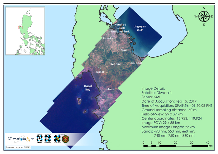
Lingayen Gulf and Dasol Bay
Lingayen Gulf, a key area for capture fisheries, aquaculture, and tourism, is a concave catchment that is bounded by the provinces of Pangasinan and La Union. During the dry season, northwesterly winds prevail in it while during the wet season, the southwesterly winds dominate its area. The physical environment of the gulf is greatly affected by the topography and bathymetry on the coast. Moreover, it also serves as the drainage of five major rivers: two flowing northwest from La Union and three flowing northwards from Pangasinan³. Four rivers can be seen in the Diwata-1 image (Figure 2). Sedimentation, due to the sediment loads from watershed and mines that are transported through the river channels, is visibly apparent on the coasts of Alaminos, Sual, and Labrador (Figure 3).
This is most likely caused by activities concerning agriculture and aquaculture, urbanization, and removal of riparian vegetation — an evidence of natural as well as man-induced stress in the coastal environment. Other known anthropogenic effects that used to or is currently existing in the Lingayen Gulf are excessive fisheries harvesting, unregulated aquaculture, destructive fishing methods, and pollution³. In relation to that, it is worth noting that Pangasinan is recorded as the 4th most populous province in the country. The 2015 census states that 2.96 million Filipinos reside in the province⁴.
On the other side of the Diwata-1 image, the Dasol Bay can be seen. As compared to the Lingayen Gulf, the coastal waters of Dasol are clearer (Figure 3). There are many factors that contribute to this. For one, the bay is open to the West Philippine Sea that makes replenishment of the waters easier. There is also only one major river — the Dasol River — that outflows to the bay⁴. It is also worth noting that the towns surrounding the Dasol Bay have lower population as compared to the coastal cities and municipalities around the Lingayen Gulf. For comparison, the 2015 population of Dasol and Dagupan are approximately 29,000 and 171,000, respectively⁵. This might imply that the anthropogenic stress exerted to the coastal environments of Dasol is lesser. Finally, Dasol municipality is known for their salt industry which relies on the bay for the seawater source of the salt ponds. For the sake of their high-quality salt products, aquaculture and mining operations that affects the coastal waters are discouraged by the locals⁶.
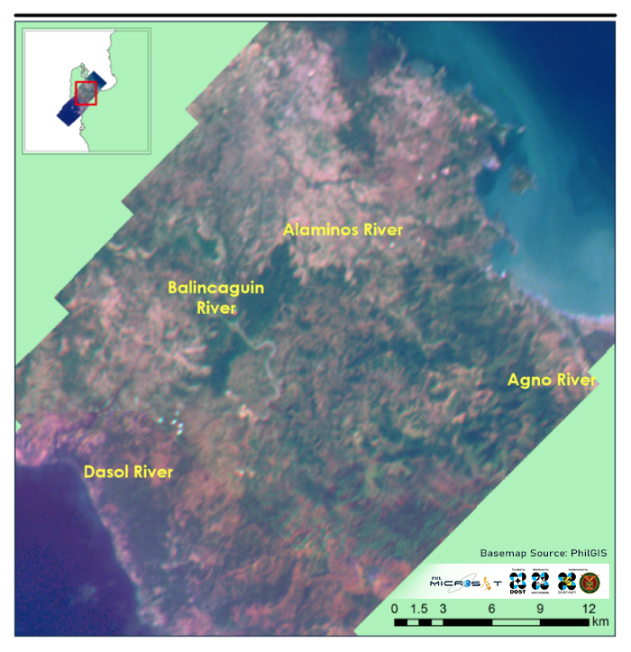
Figure 2. Major River Systems in Pangasinan

Figure 3. Difference between the sedimentation in Lingayen Gulf (encircled in red) and the clear waters of Dasol Bay (encircled in yellow)
With Pangasinan as a gateway to the north, its potential in tourism continues to grow. A member of the North Philippines Visitors Bureau’s (NPVB) Lakbay Norte⁷, Pangasinan has gathered recognition for tourism initiatives in the 2016 Pearl Awards (Best Tourism Practices of the Philippines Awards) this year for its Tourism Month celebration (1st runner-up, best provincial tourism month celebration) and Pistay Dayat, dubbed as Pangasinan’s mother of all local festivals (2nd runner-up, best provincial tourism event/festival).⁸ Aside from the renowned Hundred Islands (listed in the country’s National Geologic Monuments)⁹, the Dasol salt farms are fast becoming tourist attractions as well. According to Dasol town agriculturist Vilma Nifas, visitors even came from as far as Region IV-A (Calabarzon) and from Bukidnon (province).¹⁰
As Pangasinan’s tourism continues to soar, the images above could help existing tourism and environmental plans for sustainable development.
References
¹ The Official Website of the Province of Pangasinan and its People.“About Pangasinan.”[http://pangasinan.gov.ph/the-province/about-pangasinan/].
² Philippine Statistics Authority. “A Review of the Agriculture Sector in Ilocos Region.” [https://psa.gov.ph/content/review-agriculture-sector-ilocos-region]. 18 December 2004.
³ McManus, L. T., & Thia-Eng, C. (Eds.). The Coastal Environmental Profile of Lingayen Gulf, Philippines (Ser. 5, pp. 1–3, Tech.). Manila, Philippines: International Center for Living Aquatic Resources Management. [http://agris.fao.org]. 1990.
⁴ Philippine Statistics Authority. “Highlights of the Philippine Population 2015 Census of Population”. [https://psa.gov.ph/content/highlights-philippine-population-2015-census-population]. 19 May 2016.
⁵ The Official Website of the Province of Pangasinan and its People. “Physical Characteristics.” [http://pangasinan.gov.ph/the-province/facts-and-figures/physical-characteristics/].
⁶ Sotelo, Yolanda. “In Dasol, villages thrive in salt-making.” [http://newsinfo.inquirer.net/651612/in-dasol-villages-thrive-in-salt-making]. 19 November 2014.
⁷ Philippine Information Agency. “Pangasinan sets new sights on renewed peace, health, agriculture and tourism in 2016.” [http://news.pia.gov.ph/article/view/411454056923/pangasinan-sets-sights-on-renewed-peace-health-agriculture-and-tourism-in-2016]
⁸ The Official Website of the Province of Pangasinan and its People. “Tw more Pearl Awards for Pangasinan.” [http://pangasinan.gov.ph/2016/10/two-more-pearl-awards-for-psinan/]. 12 October 2016.
⁹ Buaron, Dave Ryan A. “Hundred Islands National Park.” [http://tourism-philippines.com/hundred-islands-national-park/]. 08 September 2009.
¹⁰ Cardinoza, Gabriel. “In Pangasinan, salt farms start drawing attention of tourists.” [http://newsinfo.inquirer.net/891651/in-pangasinan-salt-farms-start-drawing-attention-of-tourists]. 25 April 2017.
Read more about Diwata-1 or browse, download, or request for Diwata-1 images.