

The Department of Science and Technology Advanced Science and Technology Institute (DOST-ASTI) and the University of the Philippines Diliman (UPD) have been collaborating with Hokkaido University and Tohoku University to operate Diwata-1, the Philippines’ first microsatellite for scientific earth observation. The High Precision Telescope (HPT), one of the four cameras onboard the microsatellite, has successfully captured various images during the test phase of the satellite.
One of the missions of the HPT is to determine the extent of damages from natural hazards such as typhoons and volcanic eruptions. It has a nominal ground resolution of 3m at nadir, the highest resolution so far in the 50-kg class microsatellite. In the figures below, images taken by Diwata-1’s HPT and by Landsat 8’s Operational Land Imager (OLI) are compared. The ground resolution of Landsat 8’s OLI is 30m. Landsat 8 is an American Earth observation satellite with a launch mass of about 2,600 kg.
Figure 1 shows the RGB composite (normal color) images taken by Diwata-1’s HPT at 9:07 AM Philippine Standard Time (PHT) on 19 May 2016 and Landsat 8’s OLI at 10:06 AM on 21 May 2016 in PHT. The images show portions of Dumingag, Zamboanga, a mountainous area in Mindanao, Philippines. The OLI image has a 30m ground resolution, and it can identify only rough structures of the mountain but the detailed geographical features are unclear (Figure 1b). On the other hand, the HPT image can clearly identify trees, rock surface, mountain paths, river and some man-made objects (Figure 1a).
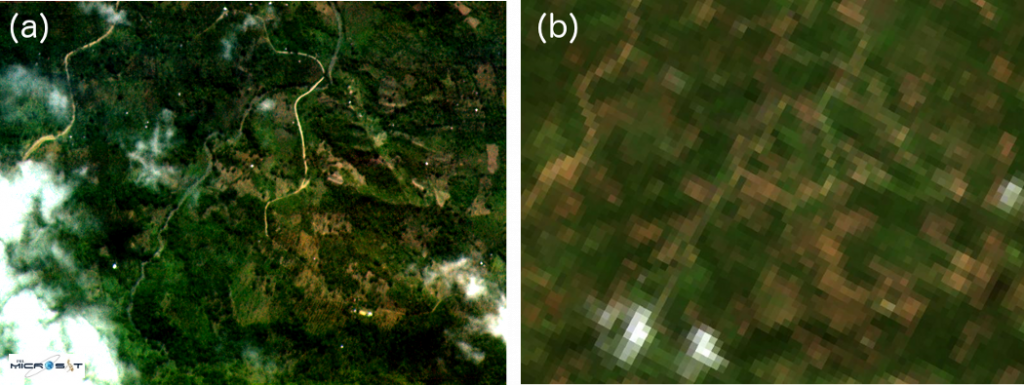
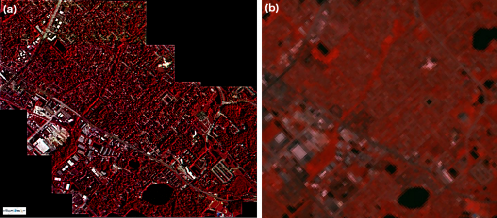
Figure 2 shows a comparison of false color images of an urban area in Florida, United States, which were taken by Diwata-1’s HPT at 7:48am Eastern Daylight Time (EDT) on 30 June 2016 and by Landsat 8’s OLI, respectively. These false color images are created to emphasize the difference between vegetation and other objects using three (3) different bands. Figure 2a is a mosaic image constructed by stitching six (6) successive images captured with 1-second interval.
As a successful demonstration of the target pointing capability of Diwata-1, the microsatellite was able to capture six (6) images of the focused area with field-of-view of 2 km x 1.5 km even though it was orbiting the earth with a velocity of ~7.7 km/s at an altitude of ~400 km. Buildings and roads are clearly distinguishable from the vegetation in the HPT images (Figure 2a), while such features are very unclear in the OLI image (Figure 2b).
The high-resolution images that can be obtained with Diwata-1’s HPT enables more accurate post-disaster assessment that can lead to timely and efficient emergency response.
Read more about Diwata-1 or browse, download, or request for images.